
Clashing worldviews
Landscapes, worldviews, Ontario Provincial Parks, forests, and images

Now I’m going to talk about ‘Parks’ as in the northern part of the globe, summer months are coming. In Ontario, in North America, ‘Parks’ are a concept devised, implemented, and used and to be utilised by Outsiders/Settlers, not the Indigenous, peoples with a worldview of those of the Group of Seven. In fact several members of the Group of Seven, A.Y. Jackson, Franklin Carmichael and A. J. Casson persuaded the Ontario Provincial Government to create Killarney Provincial Park.
The region is labelled the “North” and was captured in paintings by the painters of the Group of Seven, active and iconic between 1920 and 1933 are viewed as quintessentially Canadian. This group consisted of seven white men, once designers and illustrators, from Ontario’s southern urban centres with its Carolinian forest. But they were selected to be a group, by two individuals: Harris or Harris and MacDonald and gradually recognised from 1920s onwards as pioneers of a new, Canadian School of Art. Their paintings created an extraordinarily powerful distinct identity for white Canadians during the early 20th century as it emerged as separate and distinct with its identity forged in Vimy Ridge and the trenches of World War I. The group was led by Lawren S. Harris and included: Frank H. Johnston, Alexander Young Jackson, Franklin Carmichael, Arthur Lismer, Frederick Varley, J. E. H. MacDonald but not Tom Thompson. Thompson died before the group was officially recognized while Emily Carr is often associated with it. These men had known each other prior to World War One as they had started to paint in 1910 and reunited post-war to travel as a group to sketch the landscape and develop techniques to represent it in what they called ‘Canadian art’. The Québécois artists’, contemporaries of the Group of Seven, painted rural landscapes in contrast, containing figures. The Automatistes group of artists, led by Paul-Émile Borduas, did not emerge until the 1940s.
The ideas of modern landscape paintings promoted by the Group of Seven conflict with the North’s nature is wild, alive and kicking. But this official vision of Canada’s past as a settler colony assumes the appropriation of native land. This official identity sit uneasily on the cultural politics of erasure, exclusion, and appropriation? What about the Indigenous peoples who have lived here far long than those urban dwellers? What about the treatment of Northern Ontario’s many lakes and rivers which have been repeatedly pounded, if not depleted, by commercial fishing, its animals pushed to the point of extinction, its forests incessantly logged? The myth of an empty forest landscape, painted by the Group of Seven, is false. The Forest was never empty, nor old as it was already someone’s home: the Indigenous.
Now, Parks are a concept devised, implemented, and used by Settler groups. The system in Ontario started in 1893 with the creation of Algonquin Provincial Park, Canada’s first provincial park. It started as a small group of protected areas, the system expanded rapidly during a post-war recreation boom in the 1950s. Ontario Parks today manages over 340 protected areas covering 9.5 million hectares. Now, these Parks inevitably contain Indigenous images. Buildings were built on land used by settlers labelled cottages for urban city dwellers which were in fact ‘second homes’ for what became the quintessential Canadian ideal: “cottage country”.

By RichardBH from Hamilton, Canada - Cottage 2012, CC BY 2.0, https://commons.wikimedia.org/w/index.php?curid=54163315
This view, well worldview, entails a managed, controlled view of a forest landscape. Those who used this worldview built on the idea of the ‘wilderness’ as something to be experienced free from Indigenous folk. It’s become a place to escape from the vagaries of modern life, a place to escape to by urban Canadian city dwellers during the stifling hot summers. It’s not a place where people live or lived year round. Summer was a time to escape, to shift gear, and slow down. These ideas held by the Group of Seven regarding this landscape reflected their own origins, in the urban regions of the Province of Ontario, to the south of the Boreal Forest, with its Carolinian forest. They understood landscape as an abstract concept as a place of recreation, a wilderness landscape of scenic value and for spiritual renewal. Urban Canadians had for decades relied on rural firewood for heating and those alive at the time of the Group of Seven would have known that since the 1870s Canada began its second wave of railway expansion when some lines were built, and partly subsidized, for bringing firewood from the forests to markets in urban places. This explains the creation of plantations where trees are all one species and age, destined for their future identities, as lumber for the timber, firewood, or the pulp and paper industries. Such landscapes aren’t those imagined by the Group of Seven in the 1920s and 30s, who depicted a vision of the “ancient” forests. Those paintings are contrived – devoid of industry with a lone and majestic white pine invariably clinging to some great rock, perched high above a calm lake. These paintings hang in private collections and galleries, screaming ‘serenity, peace and calm’. A. J. Casson’s painting entitled ‘Bon Echo’ illustrates one example of a pictograph site: Mazinaw Rock.
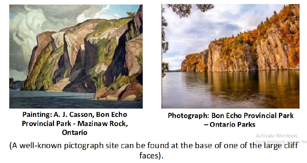
Now, this photograph from one of my powerpoints, hints the relationship between the red images called ‘art’ and landscape for a cliff face in Bon Echo Provincial Park. Just look at the map below which I’ve created for the location of pictograph (red ochre paintings) sites in Ontario:

So, there’s more than meets the eye, if you’re considering visiting one of those Parks in Ontario as ochre paintings belonging and used by the Indigenous peoples exist within several of Ontario’s Provincial Parks.
1) Quetico Provincial Park which shares its southern border with Minnesota’s Boundary Waters Canoe Area Wilderness, which in turn is part of Superior National Forest in the US. The Superior National Forest encompasses the Boundary Waters Canoe Area Wilderness.
2) Matinenda Provincial Park, Elliot Lake
3) Temagami Lake, in Finlayson Provincial Park, Temagami
4) Bloodvein River, Woodland Caribou Provincial Park, Red Lake
5) Missinaibi Lake & nearby Little Missinaibi, Missinaibi-Provincial Park, Chapleau
6) Lake of the Woods Provincial Park
7) Turtle River-White Otter Lake Provincial Park
8) Sioux Narrows Provincial Park
10) Lake Superior Provincial Park
11) Petroglyphs Provincial Park
At the same time, this forest isn’t a blank canvas of green but a living breathing ecosystem. During the summer, the forest is a myriad of greens, browns and whites with specks of bright colours from smaller plants and creatures. In the winter the colours are different. But year round, its plants and animals constantly re-colonize burnt out areas and aquatic areas such as rivers and lakes with wild rice, wild fowl, and fish. The natural rate of decomposition is slow as the build-up of litter hinders the penetration of light to the forest floor. That ‘‘litter’’ not only creates the conditions for the forest being a tinder box, a fire hazard but inhibits rapid plant growth. It’s a vibrant, living breathing place. Its dense forest is predominantly spruce. Moisture is derived from a combination of its climate, soil conditions, and topography.
In Ontario these northern forests are the Boreal Forest containing a mosaic of vegetation habitats and geographies. These are a rich mix of physical landscapes, rivers and lakes, myriad plants, insects, and faunal populations. Moisture is derived from a combination of the climate, soil conditions, and topography. Forests don’t survive in isolation and people live here. It’s a living entity in itself.
The name of this forest reflects the linguistic identity of the person doing the labelling. So, in North America, where English predominates, the words ‘taiga’ and ‘boreal forest’ are used interchangeably. The term ‘boreal forest’ is commonly applied to the broader coniferous zone while the label ‘taiga’ is utilised to refer more to the northern margins of this zone, towards the tundra where tree growth is hindered by frigid temperatures and short growing seasons. The choice of label in both scientific and geographic writing varies by region and discipline. Regardless of the region of the globe, this forest is the world’s largest land biome. But climate change is affecting it, causing it to shrink northwards as the permafrost beneath it melts and releasing carbon dioxide.
The words ‘Boreal Forest’ negates the fact that it influences human activities affecting this region for centuries. Its landscapes are connected to various conflicting views causing the creation of several groups of images. The subarctic, in Northern Ontario, contains two world views which at times conflict with one another: the western World view and animism. The Indigenous peoples, hunter-gatherers who practice animism created and use images, which will be familiar as red ochre paintings, engravings, images beaded and engraved on birchbark by the Algonquian speaking peoples (the Cree, Ojibwa and the Oji-Cree). The Indigenous people, through Norval Morriseau, from Beardmore, as he founded what’s called the Woodland School. The words (terminology) as to what to call these images reveals that two worldviews uneasily exist in this part of North America: a Settler world view and the Indigenous who practice animism. Animism is the world view of the indigenous peoples who created and use these images. These images were created in that space between the physical and the non-physical worlds of the Indigenous world.
The Park system, in not so many words, imposes a worldview of the landscape on another people, another worldview. It in essence negates the worldview of the Indigenous, and the landscape is the place where worldviews collide, and clash.