
Conversations with George:
Where is the Lac Seul First Nation in Northwestern Ontario, Canada?

So, where is the Lac Seul community in Northwestern Ontario, Canada?
So, let’s have a bit of a recap of where Lac Seul First Nation lies on the southeastern shores of Lac Seul (50°09’ N, 92°12’ W, Figure 2). Reserve #28 is located 150 kilometres northwest of the town of Sioux Lookout, 448.3 km northwest of Thunder Bay, the nearest big city, on the northwest shore of Lake Superior.
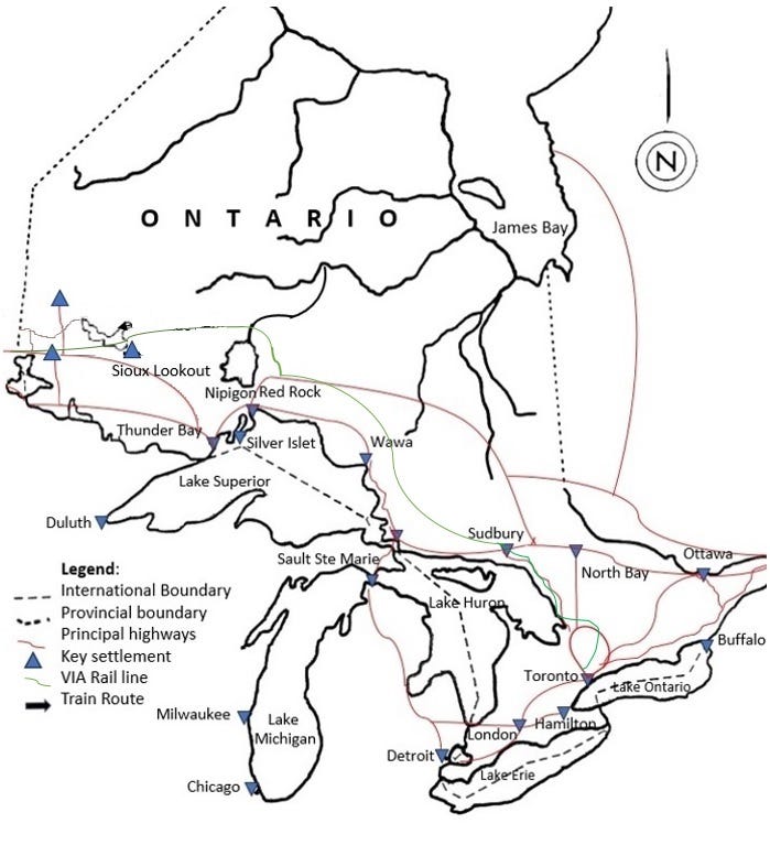
Map of Lac Seul First Nation in North America (©AliciaJMColson)
Now George when he started to talk about how he wished to discuss what Outsiders call ‘animism’ in Lac Seul First Nation, he knew that I knew a fair amount about this region. He was very upfront when I met him on zoom as he said “I know who you are “. He’d told me where I’d worked as a researcher, field archaeologist and as an ethnohistorian, who I’d worked with in many instances and had trained me – right down to the identity of my PhD supervisor and that he’d worked with Georges Sioui, who is Huron-Wendat, and who was on my doctoral committee. It was more of an interview, than a opening conversation. So, I knew that George knew the background of the people (Insiders and Outsiders) in his Teaching Circle, which I joined.
George described his community as,
“We speak our languages (Algonquian speaking people) in our area: Ojibwa (Severn Dialect) and Cree. We were a mixture of Ojibwa, Cree, and a few Sioux who arrived here through warfare. Fights were fierce and violent. Ojibwa and Cree banded together and drove the Sioux back to today’s North Dakota and Manitoba. Those who stayed behind were adopted”.
So, now I’ll provide some background details on this geographical region so that everyone knows more about this region before discussing the vegetation and proceeding on with the discussions with George, and the Teaching Circle.
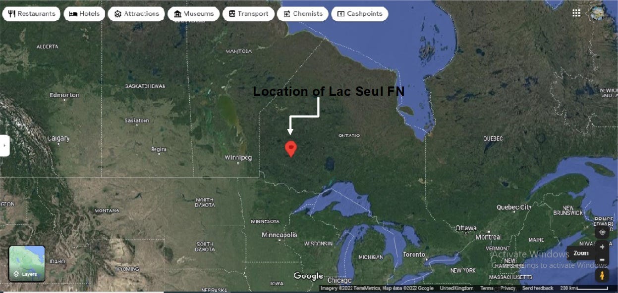
Location of Lac Seul First Nation (Google Maps)
The nearest community (town) to the Lac Seul First Nation is Sioux Lookout. It is the nearest Outsider town, using George’s term. It has a population of 5,838 people and it’s known locally as the “Hub of the North” or is a jump off point to the ‘North’ i.e. Northern Canada. It is a town serviced by the Sioux Lookout Airport, Highway 72, and the Sioux Lookout railway station. Sioux Lookout is a key airport hub for numerous northern and Indigenous communities in Northwestern Ontario and it is a service stop for the transcontinental passenger train, operated by Via Rail called “The Canadian/Le Canadien) on its Western Canada service. It travels twice weekly between Union Station in downtown Toronto, Ontario and the Pacific Central Station in Vancouver, British Columbia. This station is the railway junction for the Northwestern Ontario segment of Canadian National Railway’s transcontinental Class 1 railroad.
The downtown of the community, of Sioux Lookout, is 71 kilometres (44 miles) from the Trans-Canada Highway, and the municipality covers the ends or start of provincial highways 664, 642, 516, and 72. Thunder Bay, on the northwestern shore of Lake Superior, is the nearest city and is roughly 297 km from the Lac Seul First Nation. Lake Superior is the western most of the Great Lakes. Lac Seul is roughly 3 to 4 hours by car/truck using the Trans-Canada Hwy/ON-17 E. If you take the bus, then you have to get a lift from someone to the bus station in Sioux Lookout to where its possible to catch a bus to Thunder Bay.
Thunder Bay is considered one of the region’s six largest cities in what’s called ‘Northern Ontario’. It’s metropolitan area has 108,843 people according to the 2021 Canadian census. This area consists of the city of Thunder Bay, the municipalities of Neebing and Oliver Paiponnge, the townships of Gillies, O’Connor, Conmee and Shunian and the Fort William First Nation.
Now, I knew, and George explained that Lac Seul First Nation is one of the largest Indian Reserves in the Treaty #3 in Northwestern Ontario. (I’ll be explaining Treaty #3 and these number treaties in a subsequent substack post.)
The area called ‘Northern Ontario’ by the Provincial Government of Ontario covers 90% of the Province of Ontario’s landmass and in 2026, according to the website, represents 6% of the Province’s population.
Northern Ontario is home to 150 municipalities and 106 First Nations. Twenty eight of these communities are unconnected which means these communities are only accessible by air travel or air travel and routes such as ‘winter roads’ (which are roads built on and made from ice). The website states that all of the fly-in communities (27 out of 28) are First Nations as the majority are found in the Northwestern region of the Province. Northern Ontario, as this region is labelled by the Ontario Government, has more Indigenous Peoples, than in the rest of the Province. It has 17% of the population when compared to the province (3%) and Canada (5%). If one breaks down this number in Northern Ontario, 69% were First Nations, 29% Métis, and less than 1% Inuit.
Now the Lac Seul First Nation is part of the Anishinabek Nation which represents thirty-nine First Nations throughout the Province of Ontario from Algonquins of Pikwakanagan in the east, Aamjiwnaang in the south, Fort William First Nation and Namaygoosisagagun in the north. The website states
“The thirty-nine First Nations have an approximate combined population of 65,000 citizens, one third of the Province of Ontario’s aboriginal population. The Anishinabek Nation has four strategic regional areas Southwest, Southeast, Lake Huron and Northern Superior and each region is represented by a Regional Grand Chief.”
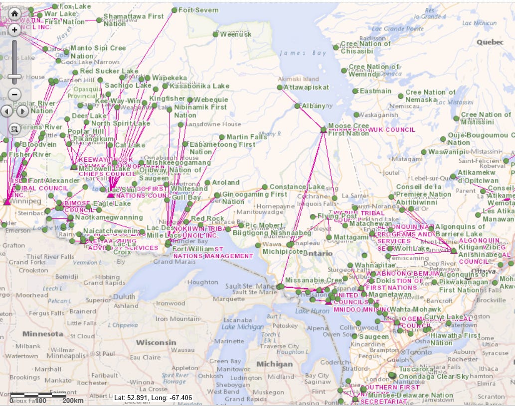
The First Nations Communities in Ontario, Canada [https://www.atlas101.ca/pm/courses/toronto-ppg1007/maps-locating-first-nations-communities-in-ontario/]
Physical location of the Lac Seul First Nation
The Lac Seul First Nation lies on the shores of Lac Seul, as I said earlier, and it is a crescent-shaped lake, a reservoir. The lake itself is approximately 241 km in length, with a maximum depth of 47.2 m, with a surface elevation of 357 m above sea level. It has 3,000 miles of shoreline, and covers over 560 square miles (358,400 acres). It’s considered the seventh-largest lake in Ontario and the second-largest lake entirely within the province. The largest lake in Ontario, is Lake Nipigon which lies to the south of Lac Seul. Today it spans from the community of Ear Falls in the west to Sioux Lookout in the East. This lake is part of the English River Watershed which drains westward via the Winnipeg River to Lake Winnipeg, and to the Arctic Ocean via Hudson Bay.
Now it is wise to remember that Lac Seul has been a reservoir since February 28, 1928. Why? The Provinces of Manitoba and Ontario sought to supply water for hydro plants from the English and Winnipeg Rivers (Lac Seul Conservation Act). In 1928, Ontario Hydro built a dam at Lower Ear Falls, where the waters of Lac Seul flow into the English River in order to make the lake a reservoir. Over the next few years, water levels increased. In 1935, the water levels were raised again to the levels which it is today, which is about 10 inches higher than the original levels. This increase in water levels didn’t just raise the waters of Lac Seul but it also raised the water levels of several nearby lakes, Route Lake and Williams Lake. The increased water levels obliterated sacred burial grounds, homes, berry patches, fields, and pictograph sites (what Outsiders call ‘rock art sites”). Today the First Nation comprises three settlements: Frenchmen’s Head, Whitefish Bay, and Kejick Bay as the fourth settlement, Canoe River, was obliterated by ‘flooding’ in the 1930s. Ironically, despite the fact that Ontario Hydro had built a dam to generate power, the company did not provide the communities of Frenchman’s Head, Kejick Bay, and Whitefish Bay with power for decades. The area where Kejick Bay exists also became an island and the community was isolated until 2009 when a 600m causeway was built to connect to the rest of the First Nation.
George explained that the view from the Outsider (i.e. the person who isn’t from the Lac Seul First Nation) must understand that,
“Lac Seul was first drawn (mapped) by Peter Pond, a fur trader based on exploration of a huge area of northwestern North America and contributed to Alexander MacKenzie’s map of 1789. The information for Peter Pond’s maps came from his explorations and from the First Nations peoples he encountered.”
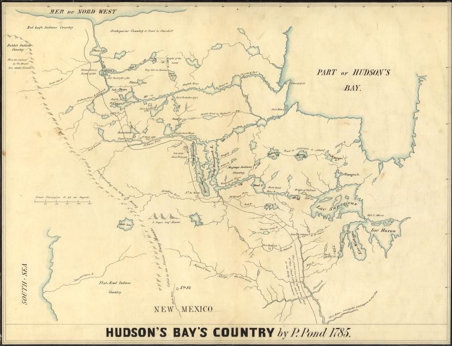
Kohl, J. G. & Pond, P. (1850)Hudson’s Bay’s country. [Map] Retrieved from the Library of Congress, https://www.loc.gov/item/2002622133/. Library of Congress, Geography and Map Division, Louisiana: European Explorations and the Louisiana Purchase.
The next substack discusses the history of Lac Seul First Nation as explained by George and vegetation of the region. This might sound odd but it’s necessary to understand the role of the Boreal Forest in the history of this region because George’s community is described as ‘hunter-gatherers’ by Outsiders.
Now, as I type, I’m hearing from friends that the forest fires are worse than usual. As I write, there are 884 fires burning across Canada today, and 124 of them are officially ‘out of control’ according to Canada’s national wildland fire summary. More than 100 of those are in Ontario.
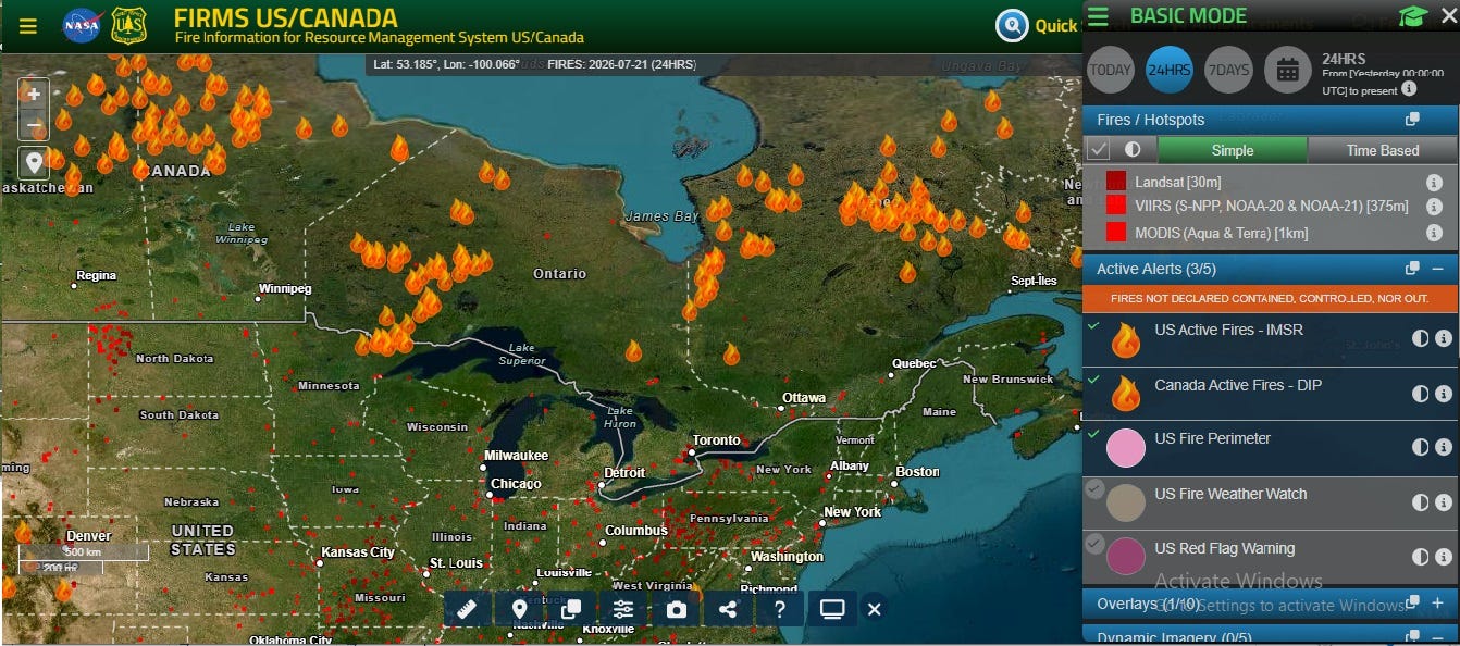
Screenshot of the forest fires on 21st July 2026. Via this site: https://firms.modaps.eosdis.nasa.gov/usfs/map/#d:24hrs;@-84.7,50.5,5.0z
These fires aren’t unprecedented, they come yearly, but they’re larger every time. Now is you look at the maps se
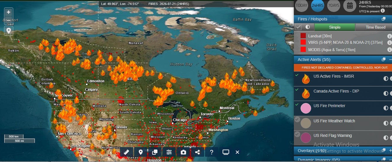
Many of these fires are where the Indigenous peoples live and account for more than 42 percent of all wildfire evacuations. About 80 % of the majority-Indigenous communities exist in fire-prone boreal regions due to the Indian Act, colonial reserve policy (to be discussed in a later substack post). Now the UN literature states (on websites), as do people from government bodies, and researchers in print that these Indigenous people hold vital ancestral knowledge and expertise on how to adapt, mitigate, and reduce climate and disaster risks, and manage biodiversity for millennia. Data from the Canadian Federal government, reveals that 70,824 Indigenous people (called First Nations in Canada) have been evacuated due to wildfires in the past decade. In 2023 alone, 25,000 people from 79 First Nations were displaced meaning more than 11,400 of them have left their homes for more than three months – they are climate refugees.
Next substack: The Boreal Forest, the landscape of the Lac Seul First Nation, and the use of fire in this region.
Interesting historical parallels to Lake of the Woods with hydropower at Kenora raising the lake levels.
Great article! That map made by Peter Pond is really interesting too. I'm looking forward to the next article on local vegetation and indigenous fire use in the region